By Alan Hoffman, March 17, 2021
The pandemic has given metropolitan regions the opportunity to rethink assumptions about planning (see Shiramizu, Rhoades, Marks, and Schuppert). Many are now questioning the use of public space, much of which historically has been given over to vehicles (see Pontarelli).
In addition to the challenges of sustainability, resilience, and “smart growth,” the Black Lives Matter movement has highlighted the inequities in planning (see Sarkin and Tyler), adding additional impetus to the search for new frameworks.
A process for better outcomes
Transportation planning can lead to better outcomes by embracing a learning process approach and by inverting the order of planning, essentially asking the question, “What can this mode do for the region if we optimize infrastructure?” This approach — Advanced Urban Visioning — allows solutions to emerge through a process of optimization, in which attributes that are valued by potential users are maximized while attributes that detract from end-user perceptions are minimized.
A “learning process” approach
Too often, transportation projects are pushed through with no clear sense of whether they will be able to solve identified problems. Planners and politicians jump to efficiency and expansion before effectiveness is ever established.
The problem is at least a function of learning process:
- First and foremost, we need to learn how to produce the desired outcomes, even if it seems cost-prohibitive at first;
- Once effectiveness is demonstrated, we can focus on efficiency — how to achieve results with fewer resources; and
- We can then learn how to replicate that success.
Learning how to be more effective
One barrier to success is the lack of vision as to how any particular network — whether bikeways, transit, trails, or parks — can maximize its utility to a region.
This dynamic is at work in the Bay Area. Dan Marks, reviewing Plan Bay Area, noted, “We need new approaches — and soon. The Plans Bay Area have … failed to establish a compelling vision of that future, or to identify what needs to change in ‘business as usual’ to get us there.”
We need to learn how to create networks that achieve ambitious goals. Once planners learn how to produce a desired solution, they can then engage in value engineering.
A perfect example of learning process: Curitiba’s BRT
Curitiba, Brazil, didn’t set out to invent BRT. They first identified what their ideal rapid transit network should look like: a metro system with five arms and several ring routes.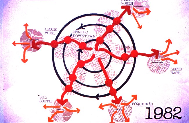
Subways are expensive, so Curitiba’s leaders decided to replicate their ideal subway system on the surface, running extra-long buses along dedicated transitways in the centers of their major roads with stations spaced three to a mile. ![]() This transit corridor in Curitiba features a dedicated center-running busway with most traffic relegated to parallel roads.
This transit corridor in Curitiba features a dedicated center-running busway with most traffic relegated to parallel roads.
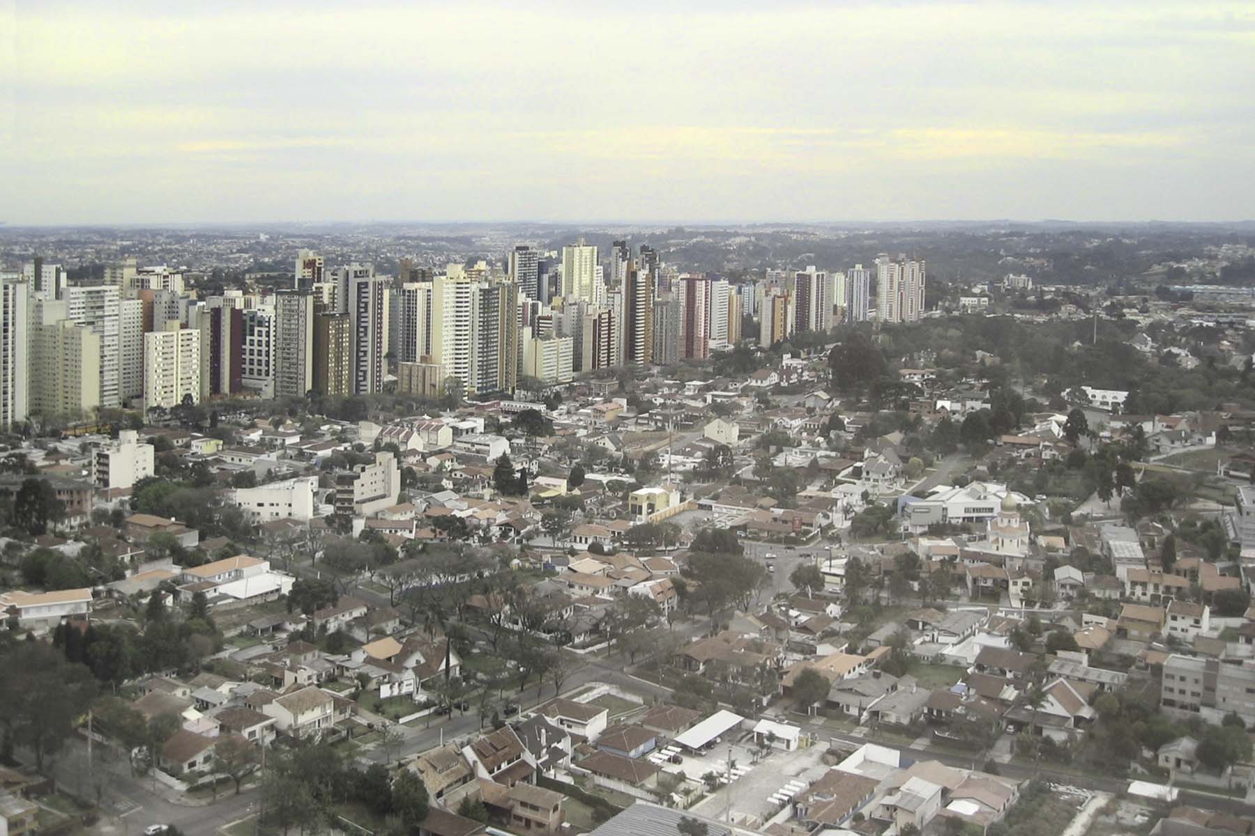
The strategy was tied to a land-use plan that placed most of the region’s denser land uses within one block of surface subway lines. Use of transit for commuting rose from about 7 percent in the early 1970s to over 70 percent by the 2000s. As a look at its skyline reveals, the city developed around its transit network.
An integrated approach
What Curitiba did was not “just” BRT. It also involved shifting traffic to parallel streets (which became one-way, signal-timed, smooth-flow roads). This allowed Curitiba to create, in less than three decades, a widespread transit network that systematically reduced travel time to most destinations.
Curitiba grew around its transit system by restricting high densities to transit corridors. This strategy preserved single-family neighborhoods (below) and reduced the impacts of new growth.
Invert the “order of planning”
Most regional strategies embrace the importance of transit and bicycling, yet their importance is rarely reflected in planning, especially at a regional level. The order of planning reflects the priority assigned to different modes — the starting point for thinking bigger.
Most regions begin their transportation planning by focusing on optimizing their automotive systems, often where road congestion is at its worst. The logic is impeccable: most people drive, and too many transit and bicycle projects have only shifted a relatively small number of trips.
Once the automotive system is optimized, transit must then fit around the automobile. In most places, transit either shares the right-of-way with cars or is delayed by traffic signals and cross-traffic. Pedestrians must then fit around car traffic and transit, and bicycles are asked to fit around everything else.
Advanced Urban Visioning
“Advanced Urban Visioning” begins with allowing an ideal transit network to emerge from a detailed analysis of urban form and trip patterns. The goal is to connect more people more directly to more likely destinations in less time, with an experience that makes them feel good about choosing transit. These standards imply a design approach over an engineering approach to planning for infrastructure.
ReX: an optimized express transit network
ReX, the Bay Area regional express transit network I helped develop for TransForm and SPUR at the request of the Metropolitan Transportation Commission (MTC), is designed to take advantage of a parallel proposal to create a more robust network of tolled express lanes on the region’s freeways.
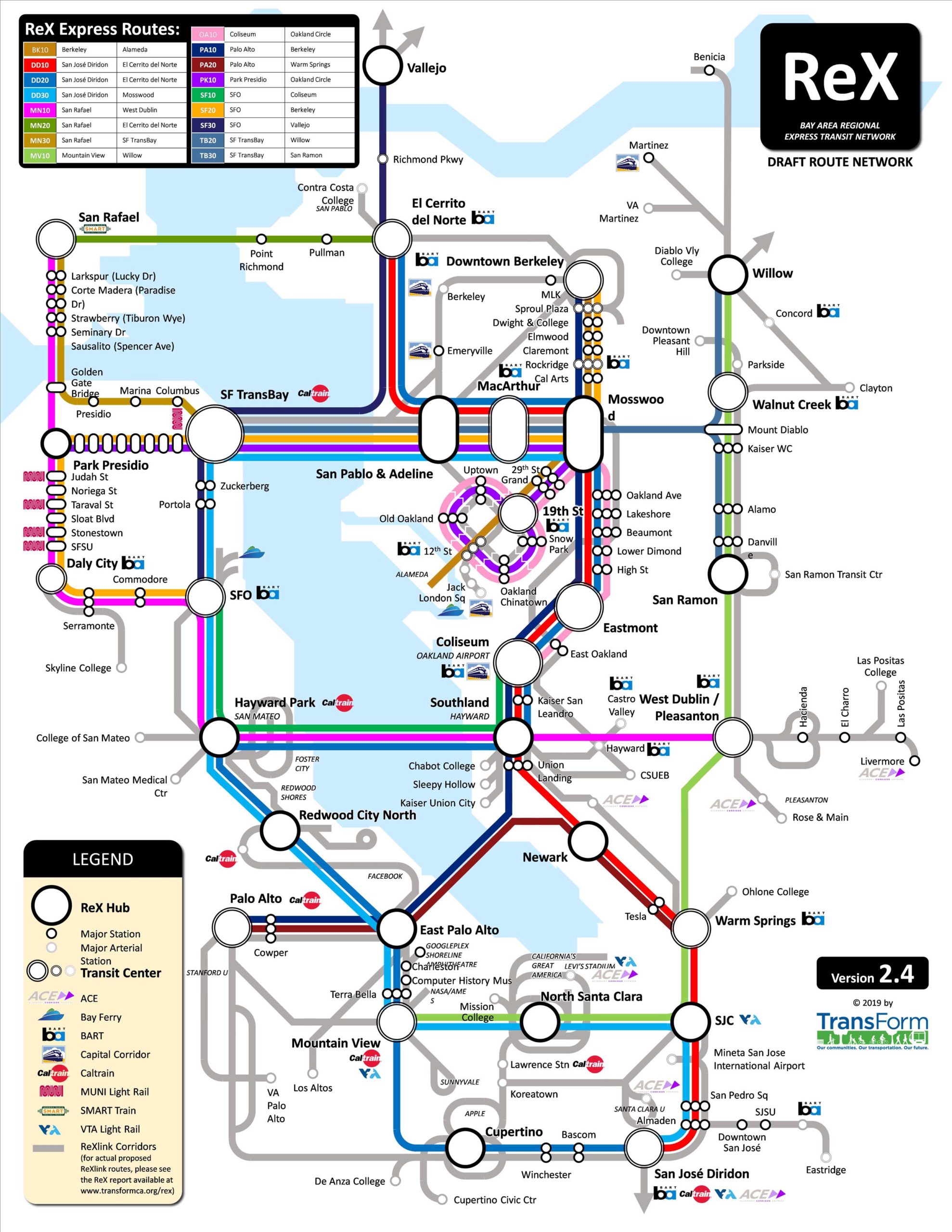
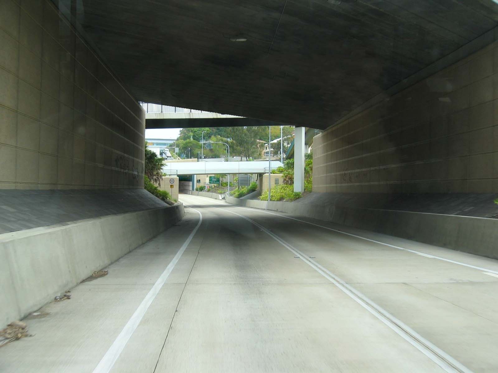
As ReX was designed to knit together the region’s transit networks and bring most major destinations within reach of the entire region, it couldn’t rely solely on express lanes. For example, downtown Berkeley has a BART station, but many surrounding destinations are too far from it, leading to excessive travel times by transit for many trips. ReX deals with this via a set of bus tunnels in Berkeley and Oakland that, together, radically cut travel times and maximize transit access to and from this dense urban zone.
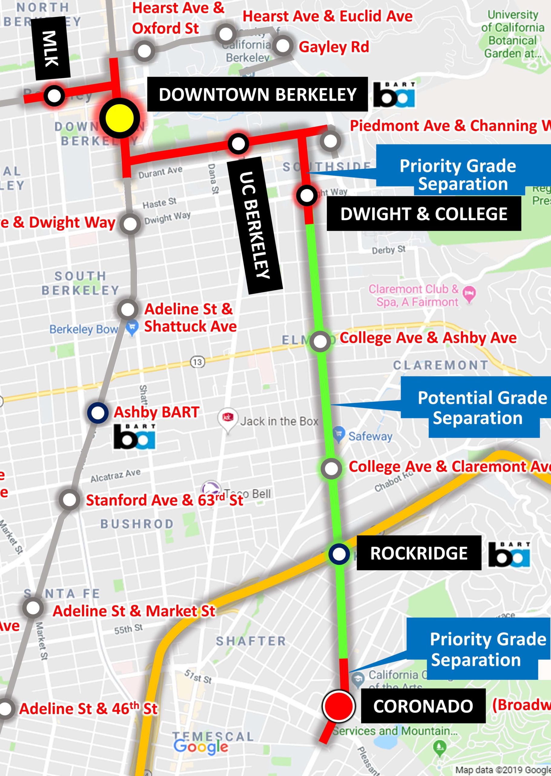
At this point, many planners roll their eyes. Bus tunnels? Billions of dollars? All fair concerns, but if the goal is to create a transit network optimized for the region, then you can’t write off major destinations. “Self-censoring” by planners unwilling to consider what it would take for BRT to be effective is counterproductive. The goal should always be to maximize the effectiveness of the hundreds of billions of dollars invested in regional transportation plans for large metro areas.
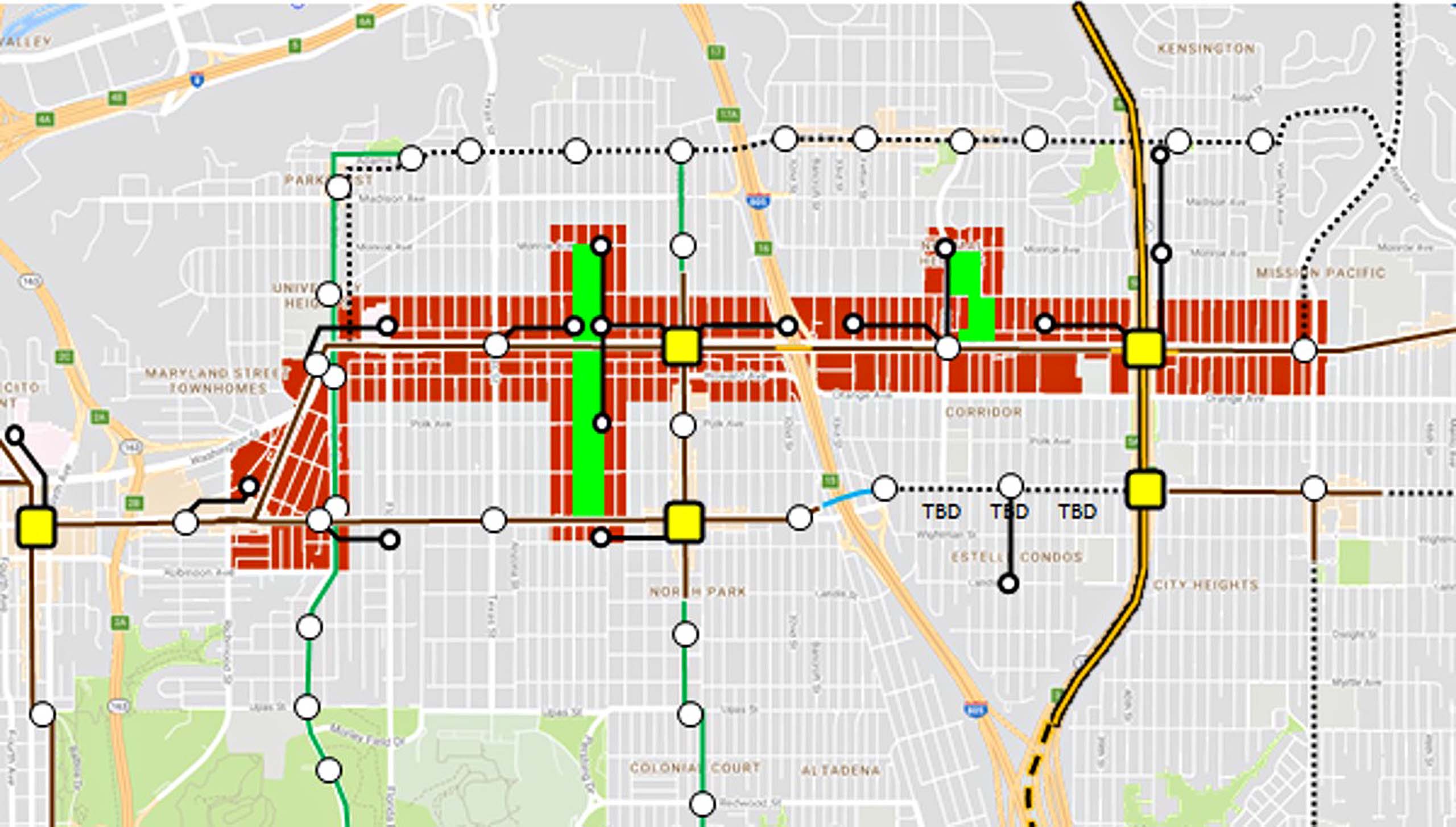
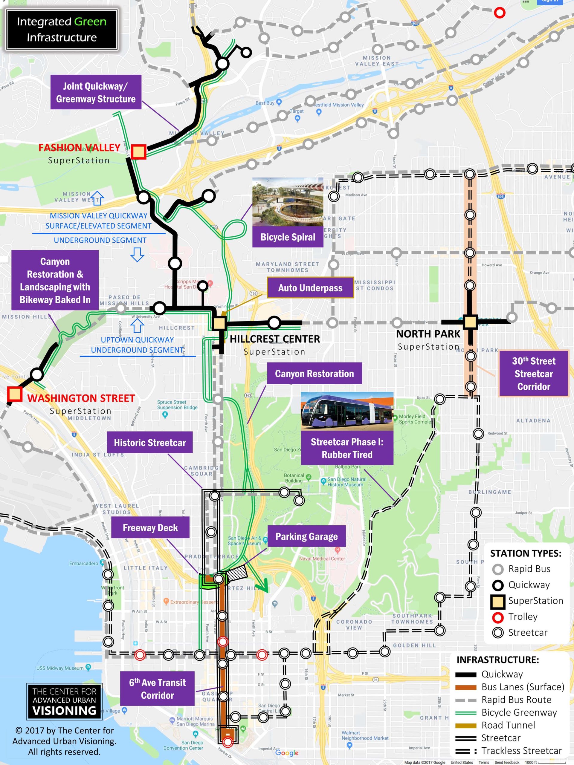
For example, a regional transit vision plan for San Diego featured infrastructure that permitted direct connectivity to most regional destinations, and it would be 25 percent cheaper to build than the then-official plan, even with several miles of such tunnels.
Leading with transit
Transit, not the auto, should be the starting point for any regional plan that seeks a major shift in how a region grows. Stations, in particular, need to be located where they will do the most good; even short distances in the wrong direction can make a big difference in effectiveness. As Robert Cervero discovered, the better matched transit is to a city, the better it can shape future growth.
Getting from an idealized transit network to an actual plan happens through a staging strategy that may take over whatever existing road infrastructure is needed, specifying new infrastructure where necessary to meet strategic goals. At this stage of planning, transit is free to take space from the auto, or to specify costly infrastructure if it solves the problem.
An ideal bicycle network
Once an optimized transit plan is identified, the next step is to develop an idealized bicycle network. Drawing on lessons from the Netherlands, the network should be designed and optimized to provide coherent, direct, safe, and easy-to-use separated bikeways to minimize conflicts with vehicles and pedestrians. This approach prioritizes bicycles over cars when allocating space in public rights-of-way.
People space
The third step in Advanced Urban Visioning is to use major transit nodes to create new “people space”— walking paths, public plazas, parklands, and open space trail networks, potentially on land currently used by cars.
Only after transit, bicycles, and pedestrians are accommodated is it time to optimize for autos. But when these alternative modes are optimized, they become easy, convenient, and time-competitive with driving, and many people will shift to them from personal vehicles. The auto will no longer be needed to move people to denser nodes.
A strategic approach to planning
Advanced Urban Visioning turns the planning process into a strategic process. Its power lies in its clear targets. Projects can stage their way to the ultimate vision, creating synergies that amplify the impacts of each successive stage.
Advanced Urban Visioning doesn’t conflict with mandated planning processes; it precedes them. For example, it may identify the need for specialized infrastructure that might not otherwise be apparent to planners.
Conclusion
Advanced Urban Visioning offers a powerful tool for regions that are serious about transforming their sustainability and resilience. It clarifies what optimal transportation networks look like for a region. It can give planners and the public a better idea of what is possible. And it inverts the traditional order of planning, ensuring that each travel mode makes the greatest possible contribution toward achieving future goals.
In Part 2 of this article, I will show how regional travel models can be updated to incorporate insights from market research, allowing planners to potentially capture many new trips for more sustainable modes.
 Alan Hoffman is a founding fellow of the Center for Advanced Urban Visioning and an Equity Consultant to the Oregon Department of Transportation. He has consulted to the SFCTA on transit planning for the Bayshore community and developed TransForm’s Bay Area Regional Express Transit Proposal (ReX) for MTC. Hoffman holds an MS in planning from MIT, a master’s in administration, planning, and social policy from Harvard, and a BA in social relations from Cornell. He is the author of Sails to Trails: Reimaging San Diego’s Historic Growth Corridor, and the Federal Transit Administration’s Advanced Network Planning for Bus Rapid Transit. He resides in Walnut Creek. You can reach him at urbanvisioning@outlook.com.